
THE CROWE RIVER, WHERE IT ALL BEGAN
Methuen Lake
Paudash Lake
Wollaston Lake
(Part of this description is borrowed from Wikipedia)
The Crowe River Course
For a great map of the Crowe Watershed, click here.
Before reaching Marmora, the Crowe River will pass through three counties. The river begins at Paudash Lake and exits southeast out of the lake under Ontario Highway 28 and over Paudash Lake Dam at the settlement of Paudash in Faraday township, Hastings County.
For more on Paudash Lake by Wikipedia, CLICK HERE
North River out of methuen lake
Old photo of Burnt dam
New Trail Bridge at Burnt Dam, Round Lake
Burnt Dam on Round Lake
North river between Round and Belmont Lakes

From Paudash, it turns southwest and heads through the southeast corner of the township of Highlands East in Haliburton County, then south into the township of North Kawartha in Peterborough County. The Crowe River heads south-southeast back into Hastings County at the township of Wollaston and passes through a dramatic 33 foot gorge (755 ft long, & 30-metre (98 f)-high) at The Gut Conservation Area.
The Gut is a geological feature and conservation area east of Apsley, Ontario, Canada, with unusual Precambrian rock formations and a waterfall. A branch of the Crowe River which passes through the conservation area flows over an exposed basalt lava ridge, part of the Canadian shield, then turns sharply and cascades into a deep gorge formed by a fault in the ridge, continuing downstream in a series of rapids and pools. Click here for tourist pamphlet.
After passing through the Gut, the river takes in the left tributary Green River, and reaches Tangamong Lake.
The river continues out of the lake over a falls, southeast to Whetstone Lake and takes in the left tributary Copeway Creek,
the falls between tangomong and whetstone lakes
Tangomong Lake
Next the Crowe River passes into the township of Marmora and Lake at Mud Turtle Lake east of the settlement of Vansickle, heads back into Peterborough County at the township of Havelock-Belmont-Methuen, flows through Cordova Lake (a.k.a. Deer Lake)and out over Cordova Lake Dam.
ABOUT THE CORDOVA LAKE DAM:
WAYNE VANVOLKENBURG WRITES: From 1968 to 1991 when the fish hatchery closed, the water level was controlled by manually removing or adding stop logs. A stationary winch was located at each end of the stop log opening. A handle was inserted into a gear mechanism that lowered a chain with a hook on the end. After the hook was manipulated into a bar on the stop log the log was raised by cranking the handle at each end. A piece of board would be placed across each end of the stop log opening, and the log then lowered onto the boards. The chain was then loosened and removed, and the log was flipped out of the way with a cant hook.
To add a log you would roll the log to the edge of the hole, align it with the edge, and flip it into the opening, with the use of a cant hook. (usually one person on each end).Because of vandalism, it became necessary to cover the openings with steel grates that were locked in place.
Because of the water requirements for Deer Lake Hatchery, the water level was maintained, as close as possible, to a constant level. At times during the spring run-off we were at the mercy of mother nature.
The hatchery water line intake had grates and screens that had to be cleaned daily to maintain the water flow for our operation, as well as a supply to the houses. Jock used to say that he could tell when the screens were dirty because the water pressure was down in their upstairs bathroom.
When the hatchery was closed and the generating station built, the water level was controlled by a hydraulic gate. At Deer Lake they were mounted on stationary posts.
Construction of the dam at "The Foot of Deer Lake" circa 1911 Photo was taken from the Cordova Gold Mine Prospectu

1911 Dam building by Cordova Co & Pearce Co..jpg
1956 photos of the Cordova dam, from the Molly Chard collection
Ron Barrons writes: “Here’s an old photo from the early 1950’s taken of the old dam at the foot then Deer Lake, this from the Barrons Family Collection. The water flows continuously over several falls and cascades until it levels out past Scott’s Dam. It drops about 30 metres in this distance. Our farm house was just over 2 kilometres from the river at Scott’s dam, however when the river was raging in spring time, it could be heard at the farm house, in the quiet of the evening when the wind was right.
(Be sure to click on Vansickle & Cordova Lake above to find out more.)
Don't miss watching these kayakers over the Cordova Lake dam!
Scott’s Dam photo by david mills
Scott's Dam Crowe (Deer) River
A nice canoe run will take you from Scott’s dam, under the Preston Road Bridge, recently rebuilt, and down to Belmont Lake.
Deer River Bridge at Preston Road
The Crowe River exits Belmont Lake from Crowe River Bay to the east, over the Belmont Dam to Crowe Lake. In 1984 major work was done in this area, dredging the basin.
Before reaching Belmont Lake, the Crowe River (sometimes called the Deer River) offers us a beautiful display of waterfalls known as "Scott's Dam, accessible from Fish Hatchery Road.
Scott’s dam photo by david mills
Ron Barrons sent this photo. He writes
Helen Louise Jackson (1928-1943 drowned in Deer River) and Alfred Nagel Jackson (1931-1997) attended school at Rockdale, here standing by one of the trucks of the Deer Lake Fish Hatchery circa 1939 and their arrival at the Hatchery from Normandale on Lake Erie.
Removing the old bridge July 2021
Working on the round lake dam Photo by Wayne VanVolkenburg
At the time of the 100 year flood in 1976, the dams were operated and maintained independent of one another. Cordova and Round lake dams were controlled by the staff at Deer Lake Fish Hatchery. Belmont Lake was controlled by Walter Van Steenburgh. The operators maintained their lake at a level that most benefited the residents living there, with little regard for those residing downstream. The flooding in 1976 accentuated the need for some revision in this system.
A centralized reporting system was implemented whereby each dam operator would phone in the water level to a central location at Kemptville. MNR staff there would evaluate the change in water levels at each lake and determine the change in stop-log placement at each dam. This would result in a more equitable sharing of the flooding, instead of simply dumping everything downstream.
At Belmont Lake, the river system takes in the major right tributary, the North River, carrying water from Round Lake and arriving at North River Bay.
North River, Round Lake to Belmont Lake
Crowe River Bay on Belmont Lake
The boulder covered bottom of the Crowe River, east of County Road 48 was identified as an area that restricted the egress of water from Belmont Lake. After some delay, a dredging operation was initiated on the Crowe River in 1984. Most of this took place from county road 48 westward. The river was drawn down to allow equipment to enter the river bottom and remove boulders and loose debris. Removing these obstructions would help to speed up the flow during the spring run-off.


Photos by Wayne Vanvolkenburg taken outside his house on the Crowe River
tHE cROWE rIVER EXITING bELMONT lAKE (pHOTOs BY wAYNE vANvOLKENBURG)
BROWN’S BRIDGE OVER THE CROWE RIVER AT COUNTY ROAD 48
These "Brown's Bridge" construction photos were contributed by Bill Steenburgh, who in turn obtained them from Peter Gower. They are both longtime cottagers, who reside near the bridge. The bridge spans the Crowe River at County Road 48, just below the outlet from Belmont Lake. John Brown was an early settler who owned property adjacent to the bridge.
The first two photos are of the first wooden bridge. Photos 3 and 4 are of the 2nd built bridge, a steel structure.
Photo submietted by George Anderson III of Georgia, USA
2nd bridge - pre 1968 Photo submitted by bill steenburgh
Below: The 1968 construction of the cement bridge Submitted by Bill Steenburgh


Below: The old Belmont dam adjacent to Bill Steenburgh’s property on Crowe River. Bill’s grandfather purchased the property from Roger Young in 1927 Photos submitted by Bill Steenburgh


More recently, an assessment of Belmont Lake dam showed that there was a need to make the footings more secure. In 2014 a project was completed to stabilize Belmont Lake dam. Holes were drilled through the dam and into the bedrock and rods were inserted and secured.
Next, on route, the waters of the Crowe system pass Blairton and thereafter cross the county line back into the Township of Marmora and Lake at Big Island.
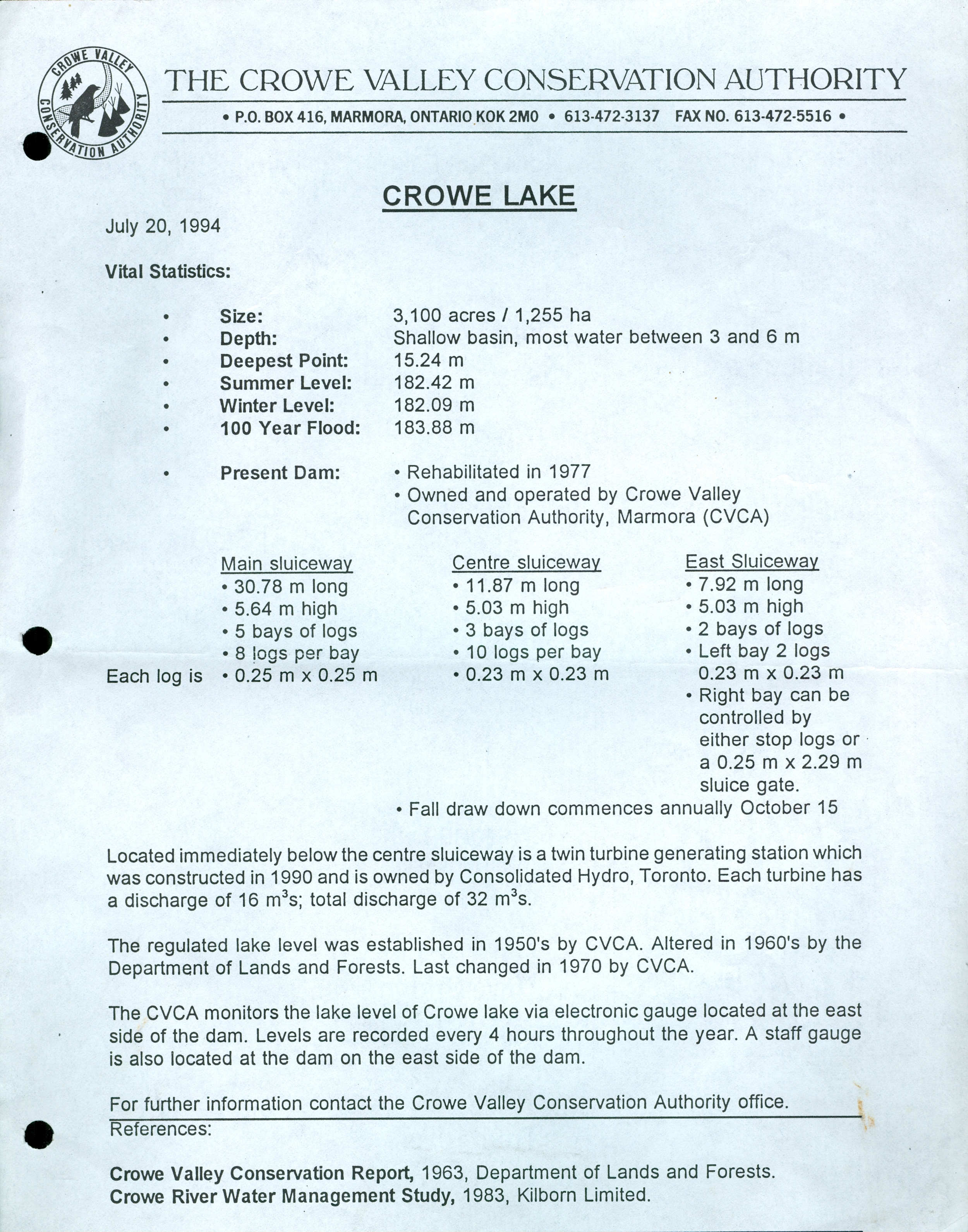
Crowe Lake Statistics
Photo of Crowe Lake by Celia Murray
The waters of Crowe Lake drain into the Crowe River again at the easterly end. This photo by Doug Prindle shows the sand bar at the mouth of the river located to the left. Just south of the mouth of the river, the Crowe takes in the major left tributary Beaver Creek, and reaches the community of Marmora , and the Marmora Dam
Mouth of the Crowe River, leaving Crowe Lake


Trumpeters swans, Crowe River
The junction of the Crowe River and the beaver creek showing the original bridge, now replaced.
Voice of the late Bob Gapes
THE CROWE RIVER IN MARMORA
The crowe river at marmora before the installation of a dam
It's hard to imagine life in Marmora in 1821, alone in the woods, cut off from the thriving Loyalists settlements clustered along the Lake Ontario shoreline. Adventurers & entrepreneurs were just starting out to explore and survey lands north of what is now Stirling - a land full ofwealth & promise, a hunting ground for the native people and a territory safe from American invasion. For Charles Hayes, who came with a dream to establish Upper Canada's first mining town, the "High Falls" in Marmora represented everything he needed - a source of food, a source of water, a source of power and a source of transportation for his iron ore and lumber. By 1823, Marmora had a population of 400, mostly lumbermen, miners and furnace workers, while Peterborough consisted of one mill run by Adam Scott and his wife. The famous pioneer, Catharine Parr Traill, had not yet arrived. The village was completely dependent on the river and as its history shows, "a lot of water has flowed under the bridge since then."
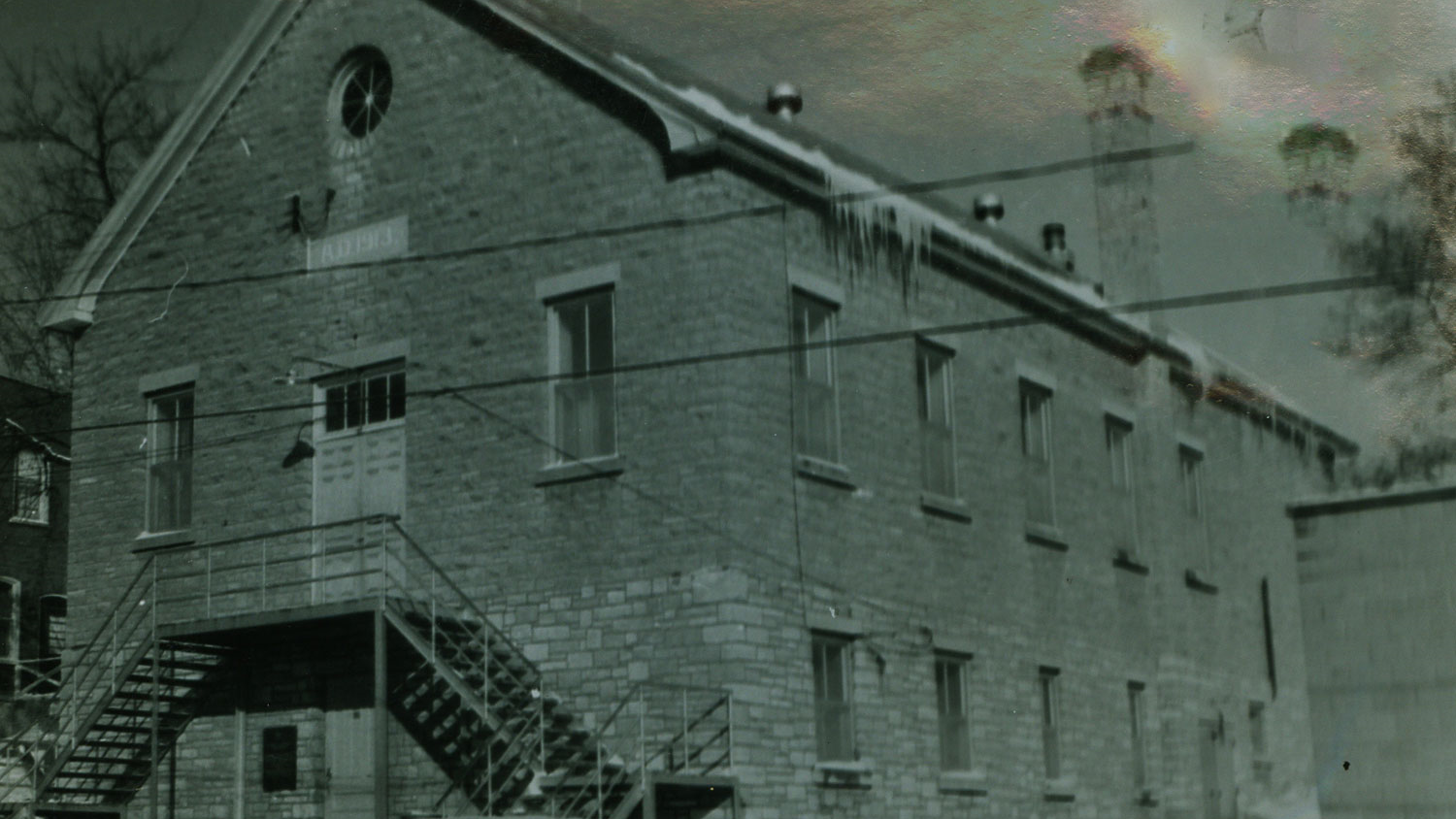
Bethlehem Steel Guest House 1952 - later the home of the Crowe Valley Conservation authority
Hughes Lane, west side of #7 Bridge, Home of the Crowe Valley Conservation Authority. 2019 Photo by Sean Scally
2019 wATER fILTRATION PLANT AND PUMP HOUSE EAST OF RIVER AT THE DAM, BUILT ON THE SITE OF THE ORIGINAL BLAST FURNACE. PHOTO BY SEAN SCALLY
Marmora, east of the river. Pump house LOWER LEFT, Dr Parkin Living centre lower right. 2019 PHOTO BY SEAN.SCALLY
You can check it all out, right here. Just click on the photos
The Pioneer Iron Town The Pearce Company The Bridges


The Marmora Dam Life on the River


Leaving Marmora
After passing over the Marmora Dam, the water of the Crowe heads southwest into the township of Stirling-Rawdon, passing over two 3 ft high and 131 to 197 ft wide falls at Callaghan's Rapids Conservation Area. Also in this area are the Marmora Maze Caves.
Click here for some nice photos.
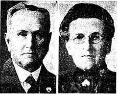
JEAN CALLAGHAN, WIFE OF JOHN CALLAGHN 1910
Entering the municipality of Trent Hills in a fourth county, Northumberland, the Crowe flows over Allan Mills dam, passes over several falls at Crowe Bridge Conservation Area, and finally reaches the Trent River at Crowe Bay , just upstream of the Trent–Severn Waterway Crowe Bay lock and dam. The Trent River flows to the Bay of Quinte on Lake Ontario at Trenton.